Site of Deadliest Native American Massacre Identified in Idaho
Blake de Pastino
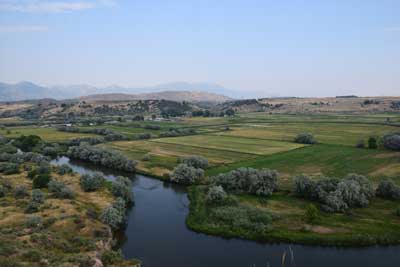
A peaceful patch of farmland in southeastern Idaho likely holds a grisly, bitter history — but the full story remains hidden, at least for now.
Archaeologists surveying acreage along the Bear River, just north of the town of Preston, say there are “compelling” signs that it’s the site of an event whose gruesomeness is matched only by its obscurity: the largest single massacre of Native Americans in U.S. history.
The researchers say their investigations may ultimately bring to light the lost story of the Bear River Massacre, a daybreak raid carried out by U.S. soldiers on a winter village of the Northwest Band of Shoshone, killing as many as 250 men, women and children on a January morning in 1863.
“It is really pretty amazing that the single largest Indian massacre is very poorly known,” said Dr. Ken Cannon, an archaeologist with USU Archeological Services who recently led a survey of the site.
“If you go through all your history books, you’re not going to find anything that’s taught [about this]. …
“So if we are able to find physical remains of the massacre, that might make it more accessible to people, to get people talking more about this event.”
Last year, the Idaho State Historical Society hired Cannon’s firm to conduct the first-ever archaeological investigation related to the incident, with a view to determining where exactly it took place and identifying any artifacts, so that the site could be commemorated as a historic battlefield.
Despite the infamy of the event, its physical legacy has been hard to track, Cannon said.
“The general area was known, but what’s been frustrating us is that there’s been so much modern construction that’s gone on there,” he said.
Traces of the destroyed Shoshone village have been all but obliterated by generations of infrastructure, from a narrow-gauge railroad laid down through the site in the late 1800s, to a canal dredged decades later, to a modern federal highway that runs nearby.
“We have a sense of where the pieces and parts were, but actually finding the exact location, that’s been frustrating in some respects,” Cannon said.
“But it’s archaeology, and it’s a process that we just have to work through.”
[See a recent discovery from the late 1800s: “‘Mysterious’ Winchester Rifle From 1882 Found Leaning Against Tree in Nevada National Park“]
Among the tools his team has called on are three historic maps, drawn by witnesses of the massacre, which have helped the researchers identify landmarks and ultimately recreate what Cannon calls “that one horrible morning.”
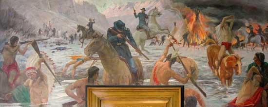
A mural in the Preston, Idaho, post office, painted by Edmond J. Fitzgerald in 1941, commemorates “The Battle of Bear River.” (Photo courtesy U.S. Postal Service)
According to accounts from the time, at dawn on January 29, 1863, a regiment of 200 California Volunteers approached a village where some 390 members of the Northwestern Band of Shoshone were wintering, near the confluence of the Bear River and a frozen creek.
The aim of the regiment’s commander, Col. Patrick Connor, was to “chastise” the Shoshone, as he put it in a letter to the War Department, for a series of recent raids and deadly attacks on white settlers.
Having spotted the village from a nearby bluff to the southeast, Connor sent troops down to the floodplain and across the Bear, where they opened fire.
Shoshone riflemen returned fire, killing about 14 of the Volunteers. In response, Connor sent down another wave of troops to surround and subdue the village.
“That set up what initially was a battle, but that lasted a very short period of time,” Cannon said.
“The Shoshone probably ran out of ammunition, and they were overwhelmed by the California Volunteers.
“And then that’s when it becomes a massacre, when [the Volunteers] flanked and routed the village and started killing men, women and children where they stood.”
Witnesses describe Shoshone fleeing into the frozen river, where some drowned and others later froze to death. Another account tells of a baby found alive the next day, perched high in a tree, presumably placed there by a parent in a desperate bid to protect it.
Although the final counts vary, most estimates place the toll at 23 soldiers, and approximately 250 Shoshone, killed in the span of about four hours.
Grim as they are, these depictions nonetheless give researchers clues about the lay of the land as it appeared more than 150 years ago. The course of the Bear River changed over time, Cannon explained, and the creek by the village — for a time remembered as Battle Creek — has since been diverted by irrigation projects.
“That was the most important landmark for us — to understand where the course of Battle Creek was — because that’s where the village was,” Cannon said.
“If we could identify that particular feature on a landscape and work back from there … we’d most likely have the best chances of finding an archaeological signature of the winter village.”
[Explore the site of another pivotal conflict: “First Evidence Found of Storied Battle That Stopped Spain’s Eastward Expansion“]
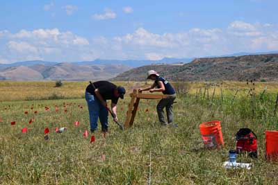
Taking their cues from the maps and other sources, Cannon’s team began surveying the land with ground-penetrating radar, magnetic gradiometer and metal detectors.

Although the land has been used intensively since the 1860s, Cannon said, these technologies can pick up traces of the Shoshones’ lodges, like rock alignments, hardened floors, and old charcoal hearths.
“We think the lodges would have a geophysical signature because they’d have a central hearth, they have rocks that ringed the lodges that kept the canvas down, and then every one of them was burned, so those things burning in place should leave a geophysical signature behind,” Cannon said.
While evidence so far is scant, the surveys have produced faint indications of where the ruined village might rest.
“We’ve got some anomalies that look really interesting,” Cannon said.
“One magnetometer image has a semicircle alignment that may be one of the lodges. So the stuff that we see coming out of the geophysics is what we see as most compelling at this point.
“But until we excavate, we’ll never know what exactly they are.”
[Read about the newly found site of another important conflict: “Plains Indian Fortress With Moat, ‘Underground Apartments’ Unearthed in Oklahoma“]
Cannon’s team will resume work this spring, using aerial thermal imaging and other methods to explore the possible lodge sites more closely.
All of the groups involved in the research, he said — from government agencies and landowners to the Northwestern Band of the Shoshone Nation — remain “very serious about protecting the heritage” surrounding one of the West’s forgotten tragedies.
“Nobody knows about these events,” he said. “They’ve been lost, and yet they’re incredibly important.
“So if we are able to find physical remains, we may be more able to make this event more visible to the general public.”
http://westerndigs.org/site-of-deadliest-native-american-massacre-identified-in-idaho/

